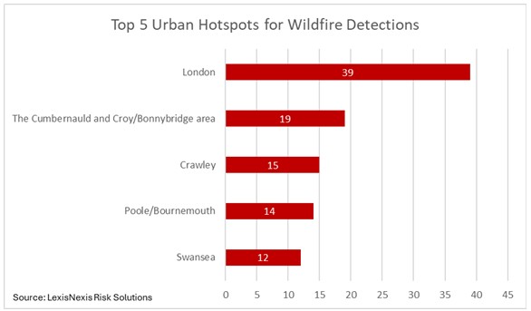
London takes the top spot with a wildfire detection referring to a fire event identified through satellite data. This analysis underscores the critical need for insurance providers to integrate historical wildfire data into both the insurance quote process and insurer portfolio management strategies as climate-related risks continue to intensify.
LexisNexis Risk Solutions analysis shows 2025 was the most severe year on record for wildfire activity in the U.K., with satellite technology recording 4,659 wildfire detections. This exceeds the previous peak of 3,305 recorded in 2018 and is nearly five times the 951 detections recorded in 2024.
The data also reveals a clear seasonal pattern in wildfires. Contrary to the common belief that wildfire risk peaks in summer, the LexisNexis Risk Solutions analysis identifies spring as the primary risk window by detection volume. In 2025, 2,635 wildfire detections were recorded in spring compared to 1,606 in summer.
However, spring and winter wildfires tend to occur, on average, almost twice as far from towns and cities as those recorded in summer months. In summer, fires move closer to urban centres, increasing exposure to property and infrastructure and increasing the potential for higher insurance claims severity. The findings are particularly relevant as fire services across parts of the U.K. respond to a series of wildfires during the current heatwave, with authorities warning of extreme pressure and elevated wildfire risk.
Caroline Elliott-Grey, senior product manager, U.K. and Ireland insurance, LexisNexis Risk Solutions, says: “Understanding the risk of wildfires spreading to homes and commercial properties has become almost as important as understanding flood or subsidence risk for property insurance providers. As we move into the peak summer months, following record-breaking temperatures in June and a dry spring[v], it is vital that insurance providers incorporate wildfire risk assessment at an individual property level, at the point of quote, to help price insurance cover accurately and fairly.
“Historical wildfire data, combined with geospatial intelligence covering weather patterns, terrain and proximity to infrastructure such as fire stations, enables insurance providers to build a location-specific view of risk. Integrating this insight into property underwriting and pricing allows for more accurate risk assessment, clearer identification of accumulations across insurance provider portfolios, and more informed decisions as climate risks continue to evolve.”
LexisNexis Analysis on Top Urban Hotspots for Wildfires
|